
A Map of the Plan of the River St. Laurence with the Operations of the Siege of Quebec
On Sept. 5, 1759
This original map showing the Operations of the Siege of Quebec was drawn by famed London mapmaker John Cary. Published circa 1810, it measures approximately 8" by 10 1/2".
This map by Cary is a fine example of his talent for very fine engraving and attractive lettering in the art and science of cartography. His General Atlas was an important publication in its day, attempting to present new information to the public.
Abstract
This map shows in great detail the most important engagement of the French and Indian War, and the largest — the Siege of Quebec in 1759.
This proved to be the decisive battle of the War in America, as the fall of Quebec marked the surrender of French control in Canada and the end of her colonial venture in America.
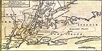
This map shows the French and British positions at the outset of the Siege of Quebec on September 5, 1759.
Here are the French encampments along the nortern bank of the St. Laurence River, together with the French redoubts and batteries "within Musquet shot." In opposition are General Wolfe's camp at the Falls of Montmerenci, and the frigates of Admiral Saunders positioned on the St. Laurence.
Shown also are other British emplacements — Major Hardy's Post, Brig. General Moncton's Camp and Admiral Holmes' transports carrying troops ready to land upstream from Quebec.
The upper right-hand corner of this map shows A View of the Action "gain'd by the British" near Quebec on Sept. 13, 1759.
The French and Indian War was the culmination of over 100 years of Anglo-French rivalry in colonial America.
After a series of minor battles between British and French forces in America, major engagements broke out between both combatants in 1755. The British, on the defensive, finally declared war on France in May of 1756.
The War in America, actually part of a general war in Europe known as The Seven Years War, ended with the fall of Quebec in 1759.
(Click on the image to receive a JPEG enlargement)