
Boston and Its Environs
Circa 1800
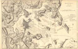
This original map from Marshall's Life of Washington shows Boston and the surrounding area in great detail. Reference points in the city of Boston include Faneuil Hall and Dock Square, the Old South Meeting House, Beacon Hill, Fort Hill, Copes alias Cops Hill, and State Street (formerly King Street).
This map offers a remarkable panoramic view of the Boston area that is linked with much of early America's history — The Boston Tea Party, the Boston Massacre, Bunker Hill and the Siege of Boston, to cite only a few of the events and their locations.
The map was published by P. Phillips, Bridge Street, Black Friars, London, on Sept. 18, 1806. It measures 8" by 12 1/2" (20x33cm).
Click on map for larger view
Popular Cities
Popular Subjects
AP History Tutors
AP Macroeconomics Tutors
Human Relations Tutors
ISEE-Lower Level Math Tutors
A Level Mathematics Tutors
Call Of Duty: Black Ops II Tutors
Competition Math Tutors
Compilers Tutors
COMPASS Reading Tutors
Roblox Tutors
English Tutors
IB Chemistry Tutors
Mandarin Chinese 2 Tutors
Honors World History Tutors
Ukulele Tutors
EMT Certification Tutors
Manufacturing Technology Tutors
Natural Language Processing Tutors
CAPM - Certified Associate in Project Management Tutors
Materials Science Tutors
Popular Test Prep
SAT Test Prep
SSAT Courses & Classes
Exam SRM - Statistics for Risk Modeling Test Prep
PSAT Courses & Classes
FAA - Federal Aviation Administration examination Courses & Classes
CRM - Certified Risk Manager Courses & Classes
ACSM - American College of Sports Medicine Courses & Classes
Spanish Courses & Classes
GMAT Courses & Classes
SSAT Test Prep